Central line
| Colour on map | Red | ||||||||||||||||||||||||||||||||
| Year opened | 1900 | ||||||||||||||||||||||||||||||||
| Line type | Deep Tube | ||||||||||||||||||||||||||||||||
| Rolling stock | 1992 Tube Stock | ||||||||||||||||||||||||||||||||
| Stations served | 49 | ||||||||||||||||||||||||||||||||
| Length | 74 km (46 mi) | ||||||||||||||||||||||||||||||||
| Depots | West Ruislip Hainault White City[1] |
||||||||||||||||||||||||||||||||
| Journeys made | 199 million (2002) (per annum) | ||||||||||||||||||||||||||||||||
|
Rail lines of Transport for London
|
|||||||||||||||||||||||||||||||||
The Central line is a London Underground line, coloured red on the tube map. It is a deep-level "tube" line, running east-west across London, and, at 76 km (47 mi), has the greatest total length of track of any line on the Underground.[1] Out of the 49 stations served, 20 are below ground. It is the second busiest line on the Underground after the Northern line.
Contents |
History
The beginnings
- For a detailed history of the line, see Central London Railway.
Although the Central London Railway (CLR) was incorporated in 1891 for a line between Shepherd's Bush and Bank (with an extension to Liverpool Street authorised in 1892) the time for completion had to be extended twice (1894, 1899); and it was not until 27 June 1900 that it was formally opened, a month before public traffic began to use the railway on 30 July to Bank station. The railway was initially operated by electric locomotives hauling a train of trailer cars. The distinctive station buildings, few of which survive, were designed by the architect Harry Bell Measures.
The tunnels were bored with the nominal diameter of 11 feet 8¼ inches (3.56 m), a diameter also used for several later lines, which was increased on curves but reduced to 11 feet 6 inches (3.51 m) close to the stations. The heavy locomotives caused considerable problems with vibration as they weighed 44 long tons (45 t; 49 ST), some three-quarters of which was unsprung.[2]
Upon the formation of the London Passenger Transport Board (by amalgamation of the CLR with other transport companies in the London area) on 1 July 1933, the railway became known as the Central London Line; on 23 August 1937 it was simplified to Central Line.[3]
In the late 1930s the tunnels were expanded and realigned and the stations lengthened. In 1940, the line was converted to the standard tube four rail electrification. Because of the manner in which tunnel had been enlarged, it was no longer round and for clearance reasons the positive rail within the original tunnels had to be of an unusual shape with the top contact surface 40 mm (1.6 in) higher than normal. This is still the situation today, and the extra height can be observed at most deep-level stations, where the insulating 'pots' stand on small cement mounds. Trains between Liverpool Street and White City must have special positive collectors that can lift higher than normal. In turn the current Central line stock cannot run on any other line, partly because they are operated by automatic train operation, have no trip-cocks, and would interfere with other signalling equipment. There are also clearance problems with the gearboxes.
One legacy of the line's building is that the sections under the City were built to follow the geography of the streets above, rather than underneath buildings, to take advantage of the free wayleave offered by the government. As a result there are many sharp bends and curves on the track between St. Paul's, Bank and Liverpool Street. At Bank station, the Central line platforms are so tightly curved it is not possible to see one end of the platform from the other and the traditional "mind the gap" message is particularly stressed here.
For several years from the outset a uniform fare of two pence was adopted: the railway was popularly known as the "Twopenny Tube". In July 1907 graduated fares of two pence and three pence were introduced: a one penny fare was added in 1909.
Extensions of the line
- 1908
- Extended in the west by means of a loop to Wood Lane Exhibition Station in 1908 for the Franco-British Exhibition.
- 1912
- Extended eastwards to Liverpool Street.
- 1920
- In the west, a short connecting link was made from Wood Lane station to join the Great Western Railway (GWR)-operated line, the Ealing and Shepherd's Bush Railway, allowing trains to run to Ealing Broadway.
- 1935
- As part of the New Works Programme 1935–40, announced in June 1935, London Transport proposed works to extend the Central line as follows:
- "to construct and electrify two additional GWR tracks from North Acton to West Ruislip, allowing Central line trains from Wood Lane to use the line;
- An extension beyond West Ruislip to Harefield Road and Denham was also planned (and shown on tube maps of the period) but was abandoned, along with the Northern Heights extensions of the Northern line, due to post-war establishment of the green belt around London which restricted development of land in the area.
- "to construct a tube railway in continuation of the Central London Line from Liverpool Street eastwards to points where it will connect with the Loughton and Grange Hill lines (probably near Leyton and Newbury Park so as to permit running through trains to stations in the West End of London and beyond without passing over the congested London and North Eastern Railway (LNER) lines at Stratford and Ilford"
- WW2
- Although the works of the latter were completed by the outbreak of war the opening was delayed, and the section, safer as it was from bombing, was used as a long, narrow, munitions factory by the Plessey company.
- 1946-48
- The eastern branch opened in December 1946 as far as Stratford (with trains continuing empty through the new tube tunnels to a temporary reversing facility at Drapers Field, in the cutting south of Leyton), with the line beyond Stratford opening as far as Woodford and Newbury Park in 1947. As for the Fairlop Loop, the southern link from Newbury Park to Ilford closed in 1947, whilst the connection to Seven Kings lasted until 1956. The Newbury Park to Woodford via Hainault section opened to tube trains in 1948, as did the section from Woodford to Buckhurst Hill. British Rail (BR) trains continued to access the line via a link from Temple Mills East to Leyton. These included the BR locomotives and stock for the Epping - Ongar shuttle (until electrification in 1957), freight trains to sidings (including Fairlop, Barkingside, Buckhurst Hill, Theydon Bois, South Woodford, Loughton, North Weald, and Ongar) until the mid-1960s, and early-morning and late-night trains between Liverpool Street and Epping (latterly formed by DMUs, and last running on 31 May 1970). This section of line now forms a loop and there are some through services to Woodford via Hainault (and vice versa), every 5 minutes or so.
- For the western extension, a new pair of tracks for the Central line opened from North Acton to Greenford opened in 1947, with the section to West Ruislip following in 1948. The powers to extend the line to Denham were never implemented. The Great Western Railway's halts and stations between Old Oak Common West junction and South Ruislip were all closed by 1948, with the shuttle to Greenford using a bay in the new Underground station.
- 1949
- Extended to Epping, when London Transport took over the line from British Railways.
- 1957
- Extended from Epping to Ongar, taking over from British Railways.
Richmond extensions
In 1912 plans were published for an extension of the line from Shepherd's Bush under Goldhawk Road, Stamford Brook Road and Bath Road to Turnham Green and Gunnersbury,[4] including stations at Hammersmith Grove, Paddenswick Road, Rylett Road, Stamford Gardens, Turnham Green and Heathfield Terrace. This would have enabled the Central London Railway to run trains through to Richmond and possibly beyond. The route was authorised in 1913[5] but work had not started by the outbreak of World War I the following year. In 1919 an alternative route was published, building a tunnelled link to the disused London and South Western Railway (L&SWR) tracks south of the L&SWR's Shepherd's Bush station then via Hammersmith (Grove Road) railway station and Turnham Green.[6] Although authorisation was granted in 1920,[7] the connection was never realised, and the L&SWR tracks were eventually used by the Piccadilly line when it was extended west of Hammersmith in 1932.[8] However the proposal has occasionally reappeared.[9]


Epping to Ongar branch
Although electrification of this section had begun under the 1935/40 New Works Programme (see above), the line remained steam-hauled (though from 16–27 June 1952 an experimental ACV/BUT three-car lightweight railcar set operated part of the shuttle service Monday-Friday) until 18 November 1957. From that date two-, three- and four-car tube trains were used on the branch. Shorter platforms at North Weald and Blake Hall, coupled with a limited power supply, meant it was not possible to work through trains to and from London, and the line remained a branch, though the shuttle service initially operated between Ongar and Loughton. Expected levels of passenger use never materialised; the line became a heavy loss maker, and was closed on 30 September 1994 and sold to the Pilot Group. The direct connection to Epping was lifted soon after closure, but the remaining section of the branch stayed intact.
A heritage passenger service owned by Epping Ongar Railway Ltd. started operation in October 2004. A train runs on Sundays from Ongar to Coopersale, stopping at North Weald, with a possible extension to Epping in the future. It does not stop at the old Blake Hall station, as the station platform was removed upon station closure in 1981.
2003 derailment and closure
A Central line train derailed at Chancery Lane on 25 January 2003, injuring 32 passengers, after a traction motor became detached from the train and fell onto the track. The entire line was closed whilst the cause of the failure was determined and appropriate modifications made to the trains. The line was then re-opened in stages. By late March 2003 a limited service was running on the eastern and western extremities of the line, with the central section still closed. Services resumed over that central section on 3 April 2003 and to all stations (albeit at a reduced frequency) on 12 April, with a full service by the end of the month. The initial closure also extended to the Waterloo & City line which uses the same "1992 tube stock" trains, but this line, being far shorter - with only two stops and far fewer trains - reopened quickly.
A more minor derailment occurred on a set of points at the London end of the westbound platform at White City on 11 May 2004, but there were no reported injuries.
2007 derailment
Three carriages came off the rails on the westbound Central line between Mile End and Bethnal Green at about 0900 BST on 5 July 2007. The cause was attributed to a roll of tarpaulin which came free from a storage location next to the lines.[10]
London Fire Brigade sent 14 fire engines to the scene, including four urban search and rescue vehicles. The line was closed between Liverpool Street and Leytonstone and re-opened on 7 July 2007.
Rolling stock
Former rolling stock

When opened in 1900, the railway was operated by electric locomotives hauling coaches. The coaches were fitted with gates at each end, similar to those used on the City and South London Railway and the Glasgow Subway. The locomotives, with a large unsprung weight, proved highly unsatisfactory and the cause of considerable vibration. They were replaced as early as 1903 with motor cars, with the existing coaching stock being adapted to run as trailers within newly formed electric multiple units.
By the 1920s the rolling stock was in need of modernisation or replacement. Given that the then-new Standard Stock was too large to work in the line's tunnels, it was decided to modernise the existing fleet. The end gates were removed and replaced by an extension to the passenger accommodation. Two air operated single-leaf sliding doors were inserted into both sides of each carriage. Reconstruction work was carried out by the Union Construction Company at Feltham.
Additional trains were purchased for the opening of the Wood Lane to Ealing Broadway extension in 1920. These were also temporarily used on the Watford extension of the Bakerloo line.
The 1900/03 stock and 1920 stock were finally withdrawn from service in 1939. With the enlargement of the tunnels and modification of the electrical supply, Standard Stock (displaced from the Northern line by new 1938 Stock) was operated - eventually as 8-car trains following platform extensions.
The Standard Stock became increasingly unreliable during the 1950s. Some had been stored during World War II pending the opening of extensions. Plans for replacement (using a production version of the prototype 1960 Stock) were abandoned; new trains of 1962 Stock (virtually identical to the tried and tested 1959 Stock) were ordered instead. These operated until their replacement by 1992 Stock in the early 1990s.

The Epping-Ongar branch was not electrified until 1957, prior to which the service was operated on behalf of London Transport by British Railways using steam hauled coaches. Upon electrification, two-car sets of 1935 Stock were initially used, later replaced by 4-car sets of 1962 Stock specially modified to cope with the limited current. The section closed in 1994, and eventually became a heritage railway now known as the Epping Ongar Railway.
The 1967 rolling stock used on the Victoria line was also used on the Central line's Hainault-Woodford section until 1984.[11]
Current trains
In common with virtually all other Underground lines, the Central line is worked by a single type of rolling stock. The 1992 Tube Stock was introduced gradually from April 1993 to 17 February 1995, and was the first in London to introduce automated announcements for connections and station stops. The 1992 stock is painted in the standard red, white and blue Underground livery and runs in 8-car sets.
In 1996 the line was fitted with automatic train operation, and this was brought into service in sections over the next few years.
Map
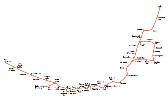
The TFL line diagram is available online.[12]
Stations
| Central line | |||||||||||||||||||||||||||||||||||||||||||||||||||||||||||||||||||||||||||||||||||||||||||||||||||||||||||||||||||||||||||||||||||||||||||||||||||||||||||||||||||||||||||||||||||||||||||||||||||||||||||||||||||||||||||||||||||||||||||||||||||||||||||||||||||||||||||||||||||||||||||||||||||||||||||||||||||||||||||||||||||||||||||||||||||||||||||||||||||||||||||||||||||||||||||||||||||||||||||||||||||||||||||||||||||||||||||||||||||||||||||||||||||||||||||||||||||||||||||||||||||||||||||||||||||||||||||||||||||||||||||||||||||||||||||||||||||||||||||||||||||||||||||||||||||||||||||||||||||||||||||||||||||||||||||||||||||||||||||||||||||||||||||||||||||||||||||||||||||||||||||||||||||||||||||||||||||||||||||||||||||||||||||||||||||||||||||||||||||||||||||||||||||||||||||||||||||||||||||||||||||||||||||||||||||||||||||||||||||||||||||||||||||||||||||||||||||||||||||||||||||||||||||||||||||||||||||||||||||||||||||||||||||||||||||||||||||||||||||||||||||||||||||||||||||||||||||||||||||||||
|---|---|---|---|---|---|---|---|---|---|---|---|---|---|---|---|---|---|---|---|---|---|---|---|---|---|---|---|---|---|---|---|---|---|---|---|---|---|---|---|---|---|---|---|---|---|---|---|---|---|---|---|---|---|---|---|---|---|---|---|---|---|---|---|---|---|---|---|---|---|---|---|---|---|---|---|---|---|---|---|---|---|---|---|---|---|---|---|---|---|---|---|---|---|---|---|---|---|---|---|---|---|---|---|---|---|---|---|---|---|---|---|---|---|---|---|---|---|---|---|---|---|---|---|---|---|---|---|---|---|---|---|---|---|---|---|---|---|---|---|---|---|---|---|---|---|---|---|---|---|---|---|---|---|---|---|---|---|---|---|---|---|---|---|---|---|---|---|---|---|---|---|---|---|---|---|---|---|---|---|---|---|---|---|---|---|---|---|---|---|---|---|---|---|---|---|---|---|---|---|---|---|---|---|---|---|---|---|---|---|---|---|---|---|---|---|---|---|---|---|---|---|---|---|---|---|---|---|---|---|---|---|---|---|---|---|---|---|---|---|---|---|---|---|---|---|---|---|---|---|---|---|---|---|---|---|---|---|---|---|---|---|---|---|---|---|---|---|---|---|---|---|---|---|---|---|---|---|---|---|---|---|---|---|---|---|---|---|---|---|---|---|---|---|---|---|---|---|---|---|---|---|---|---|---|---|---|---|---|---|---|---|---|---|---|---|---|---|---|---|---|---|---|---|---|---|---|---|---|---|---|---|---|---|---|---|---|---|---|---|---|---|---|---|---|---|---|---|---|---|---|---|---|---|---|---|---|---|---|---|---|---|---|---|---|---|---|---|---|---|---|---|---|---|---|---|---|---|---|---|---|---|---|---|---|---|---|---|---|---|---|---|---|---|---|---|---|---|---|---|---|---|---|---|---|---|---|---|---|---|---|---|---|---|---|---|---|---|---|---|---|---|---|---|---|---|---|---|---|---|---|---|---|---|---|---|---|---|---|---|---|---|---|---|---|---|---|---|---|---|---|---|---|---|---|---|---|---|---|---|---|---|---|---|---|---|---|---|---|---|---|---|---|---|---|---|---|---|---|---|---|---|---|---|---|---|---|---|---|---|---|---|---|---|---|---|---|---|---|---|---|---|---|---|---|---|---|---|---|---|---|---|---|---|---|---|---|---|---|---|---|---|---|---|---|---|---|---|---|---|---|---|---|---|---|---|---|---|---|---|---|---|---|---|---|---|---|---|---|---|---|---|---|---|---|---|---|---|---|---|---|---|---|---|---|---|---|---|---|---|---|---|---|---|---|---|---|---|---|---|---|---|---|---|---|---|---|---|---|---|---|---|---|---|---|---|---|---|---|---|---|---|---|---|---|---|---|---|---|---|---|---|---|---|---|---|---|---|---|---|---|---|---|---|---|---|---|---|---|---|---|---|---|---|---|---|---|---|---|---|---|---|---|---|---|---|---|---|---|---|---|---|---|---|---|---|---|---|---|---|---|---|---|---|---|---|---|---|---|---|---|---|---|---|---|---|---|---|---|---|---|---|---|---|---|---|---|---|---|---|---|---|---|---|---|---|---|---|---|---|---|---|---|---|---|---|---|---|---|---|---|---|---|---|---|---|---|---|---|---|---|---|---|---|---|---|---|---|---|---|---|---|---|---|---|---|---|---|---|---|---|---|---|---|---|---|---|---|---|---|---|---|---|---|---|---|---|---|---|---|---|---|---|---|---|---|---|---|---|---|---|---|---|---|---|---|---|---|---|---|---|---|---|---|---|---|---|---|---|---|---|---|---|---|---|---|---|---|---|---|---|---|---|---|---|---|---|---|---|---|---|---|---|---|---|---|---|---|---|---|---|---|---|---|---|---|---|---|---|---|---|---|---|---|---|---|---|---|---|---|---|---|---|---|---|---|---|---|---|---|---|---|---|---|---|---|---|---|---|---|---|---|---|---|---|---|---|---|---|---|---|---|---|---|---|---|---|---|---|---|---|---|---|---|---|---|---|---|---|---|---|---|---|---|---|---|---|---|---|---|---|---|---|---|---|---|---|---|---|---|---|---|---|---|---|---|---|---|---|---|---|---|---|---|---|---|---|---|---|---|---|---|---|---|---|---|---|---|---|---|---|---|---|---|---|---|---|---|---|---|---|---|---|---|---|---|---|---|---|---|---|---|---|---|---|---|---|---|---|---|---|---|---|---|---|---|---|---|---|---|---|---|---|---|---|---|---|---|---|---|---|---|---|---|---|---|---|---|---|---|
|
|||||||||||||||||||||||||||||||||||||||||||||||||||||||||||||||||||||||||||||||||||||||||||||||||||||||||||||||||||||||||||||||||||||||||||||||||||||||||||||||||||||||||||||||||||||||||||||||||||||||||||||||||||||||||||||||||||||||||||||||||||||||||||||||||||||||||||||||||||||||||||||||||||||||||||||||||||||||||||||||||||||||||||||||||||||||||||||||||||||||||||||||||||||||||||||||||||||||||||||||||||||||||||||||||||||||||||||||||||||||||||||||||||||||||||||||||||||||||||||||||||||||||||||||||||||||||||||||||||||||||||||||||||||||||||||||||||||||||||||||||||||||||||||||||||||||||||||||||||||||||||||||||||||||||||||||||||||||||||||||||||||||||||||||||||||||||||||||||||||||||||||||||||||||||||||||||||||||||||||||||||||||||||||||||||||||||||||||||||||||||||||||||||||||||||||||||||||||||||||||||||||||||||||||||||||||||||||||||||||||||||||||||||||||||||||||||||||||||||||||||||||||||||||||||||||||||||||||||||||||||||||||||||||||||||||||||||||||||||||||||||||||||||||||||||||||||||||||||||||||
In order from west to east.
| Station | Image | Opened[13] | Notes[13] |
|---|---|---|---|
| West Ruislip |
|
Terminus Opened as West Ruislip (for Ickenham); the suffix was later dropped.map 1 | |
| Ruislip Gardens |
|
map 2 | |
| South Ruislip |
|
map 3 | |
| Northolt |
|
map 4 | |
| Greenford |
|
map 5 | |
| Perivale |
|
map 6 | |
| Hanger Lane |
|
map 7 | |
| Ealing Broadway |
|
Terminus - Change for District linemap 8 | |
| West Acton |
|
map 9 | |
| North Acton |
|
map 10 | |
| East Acton |
|
map 11 | |
| White City |
|
Trains run right-handed through this stationmap 12 | |
| Shepherd's Bush |
|
Refurbished in 2008map 13 | |
| Holland Park |
|
map 14 | |
| Notting Hill Gate |
|
Change for Circle and District linesmap 15 | |
| Queensway |
|
Opened as Queens Road; renamed 1 September 1946map 16 | |
| Lancaster Gate |
|
map 17 | |
| Marble Arch |
|
map 18 | |
| Bond Street |
|
Change for Jubilee linemap 19 | |
| Oxford Circus |
|
Change for Bakerloo and Victoria linesmap 20 | |
| Tottenham Court Road |
|
Opened as Oxford Street; renamed 9 March 1908 - Change for Northern linemap 21 | |
| Holborn |
|
Opened as a Piccadilly station on 15 December 1906. Central line platforms opened 25 September 1933 and station renamed Holborn (Kingsway); the suffix was later dropped. Change for Piccadilly line.map 22 | |
| Chancery Lane |
|
Renamed Chancery Lane (Grays Inn) 25 June 1934; the suffix was later droppedmap 23 | |
| St. Paul's |
|
Opened as Post Office; renamed 1 February 1937map 24 | |
| Bank |
|
Change for Circle, District, Northern and Waterloo & City lines and DLRmap 25 | |
| Liverpool Street |
|
map 26 | |
| Bethnal Green |
|
map 27 | |
| Mile End |
|
map 28 | |
| Stratford |
|
Change for Jubilee linemap 29 | |
| Leyton |
|
map 30 | |
| Leytonstone |
|
map 31 | |
| Snaresbrook |
|
map 32 | |
| South Woodford |
|
Opened as South Woodford (George Lane); renamed 1947map 33 | |
| Woodford |
|
Terminus of Hainault Loopmap 34 | |
| Wanstead |
|
map 35 | |
| Redbridge |
|
map 36 | |
| Gants Hill |
|
map 37 | |
| Newbury Park |
|
map 38 | |
| Barkingside |
|
map 39 | |
| Fairlop |
|
map 40 | |
| Hainault |
|
map 41 | |
| Grange Hill |
|
map 42 | |
| Chigwell |
|
map 43 | |
| Roding Valley |
|
Currently least used station on the networkmap 44 | |
| Buckhurst Hill |
|
map 45 | |
| Loughton |
|
map 46 | |
| Debden |
|
map 47 | |
| Theydon Bois |
|
map 48 | |
| Epping |
|
Terminusmap 49 |
Former stations
- Denham; never connected
- Harefield Road; never opened
- Wood Lane; closed 22 November 1947[13]
- British Museum; 24 September 1933[13]
- North Weald; first served 25 September 1949; closed 30 September 1994.[13]
- Blake Hall; first served 25 September 1949; closed: 31 October 1981.[13]
- Ongar; first served 25 September 1949; closed 30 September 1994.[13]
Depots
There are three depots on the Central line; West Ruislipmap 50 near the West Ruislip station, Hainaultmap 51 near the Hainault tube station and White Citymap 52 near the White City tube station.[1]
Future plans
The developers of the First Central business park at Park Royal, west London were planning a new station between North Acton and Hanger Lane. This would have served the business park and provide a walking distance interchange with Park Royal station on the Piccadilly line.[14] This is not currently being actively pursued.
If the Chelsea–Hackney line is built then it is intended that it will take over the Epping branch of the Central line. Current hopes are that this will be completed by 2025.[15][16] This would mean that all/most eastbound services would ideally terminate at Woodford, providing a more frequent service than present for the users of Grange Hill, Chigwell and Roding Valley stations.
It would be possible to provide an interchange with London Overground at Shoreditch High Street station which opened in 2010 but current thinking is that the disadvantages to existing passengers outweigh the benefits.
Maps
|
|
References
- ↑ 1.0 1.1 1.2 "London Underground Key Facts". Transport for London. http://www.tfl.gov.uk/corporate/modesoftransport/londonunderground/1608.aspx. Retrieved 2008-05-21.
- ↑ Day, John R.; Reed, John (2008) [1963]. The Story of London's Underground (10th ed.). Harrow: Capital Transport. pp. 53,57. ISBN 978 1 85414 316 7.
- ↑ Lee, Charles Edward (May 1970). Seventy Years of the Central. Westminster: London Transport. p. 27. 570/1111/RP/5M. ISBN 0 85329 013 X.
- ↑ London Gazette: no. 28666, pp. 9018–9021, 26 November 1912.
- ↑ Central London Railway Act, 1913
- ↑ London Gazette: no. 31656, p. 14473, 25 November 1919.
- ↑ London Gazette: no. 32009, pp. 8171–8172, 6 August 1920. Retrieved 6 April 2010.
- ↑ "Central line facts". Transport for London. http://www.tfl.gov.uk/tfl/corporate/modesoftransport/tube/linefacts/?line=central. Retrieved 30 June 2008.
- ↑ "Bakerloo from Queen's Park to Ealing and Central Line from Shepherd's Bush to Richmond". Transport Plans for the London Area. 14 June 1999. http://www.geocities.com/Athens/Acropolis/7069/tpftla_w.html#BakerlooEaling. Retrieved 30 June 2008.
- ↑ "Tube route safety checks ordered". BBC News. 2007-07-05. http://news.bbc.co.uk/1/hi/england/london/6274604.stm.
- ↑ Hardy, Brian (2002) [1976]. London Underground Rolling Stock (15th ed.). Harrow Weald: Capital Transport. p. 10. ISBN 1 85414 263 1.
- ↑ TFL line diagram
- ↑ 13.0 13.1 13.2 13.3 13.4 13.5 13.6 Rose, Douglas (1999). The London Underground, A Diagrammatic History. London: Douglas Rose/Capital Transport. ISBN 1-85414-219-4. OCLC 59556887.
- ↑ First Central Business Park
- ↑ Crossrail official site
- ↑ PDF on the route options
External links
- Central line - London Underground page with line facts and brief history
- Clive's Underground Line Guide
- A History of the London Tube Maps - 1914 tube map showing proposed extension to Gunnersbury
- Epping Ongar Railway - The company currently owning the Epping and Ongar branch and running trains on it.
|
|||||||||||||||||||||||||||||||